Sign up for the paNOW newsletter

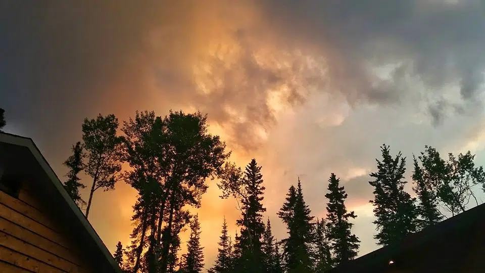
FIRE UPDATE: Three communities threatened by wildfires

Jun 29, 2015 | 4:06 PM

Saskatchewan and out-of-province fire crews are so busy protecting northern communities immediately threatened by fires that they’re not currently dealing with fires in the remote north.

As of Monday there was a direct fire threat to the communities of Montreal Lake, Wadin Bay and Sucker River, said Duane McKay, commissioner of emergency management and fire safety with Government Relations.

So far, no buildings have been confirmed lost because of value protection in those areas.

McKay said they are ramping up efforts and doing all they can to get people out of all the affected communities.

“Yesterday (Sunday) for instance, we did evacuations that went north instead of south simply because of road access,” said McKay.

Convoys of vehicles have been led on roads deemed safe by emergency crews.

He said fire activity and smoke decreases in the morning and evening, allowing them to pilot or transport people out.

“We’re looking at all those contingencies to ensure that people aren’t stuck in a dangerous situation,” said McKay.

Steve Roberts, executive director of wildfire management for the Ministry of Environment, said in the hamlet of Weyakwin, fire has come up to the edge of the community so crews are currently managing spot fires. A full evacuation of the area has been completed and so far no values have been reported lost.

Fire has also reached the community of Montreal Lake. Crews on sight are working with community members and there are no reported structural losses to date.

Grandmother’s Bay underwent a full evacuation although there is no direct fire threat at this time.

The Eli Fire is currently adjacent to the communities of Sucker River and Waden Bay. Crews have set up values protection in both communities.

“There are a number of large fires on the landscape, literally from one side of the province to the other,” said Roberts. “Some of those are in the remote areas of the north.”

They are not our priority; we have not been able to access those.”

The fire currently posing the biggest threat continues to be the Crusto Fire, adjacent to the community of Weyakwin. It covers 74 square kilometres, which is bigger in size than Prince Albert.

Crysto is directly threatening Weyakwin, the Ramsey Bay subdivision and the Weyakwin Provincial Recreation Site.

A separate fire has approached Montreal Lake.

“None of those are listed as contained,” said Roberts.

Mandatory evacuations are in place, forcing people from their homes for health reasons, due to smoke, or because of direct fire threats.

In the La Ronge area, people have been evacuated from La Ronge, Nemeiben Lake, Sucker River, Waden Bay, Ramsey Bay, Weyakwin, Timber Lake, Grandmother’s Bay, Montreal Lake, and some people from Stanley Mission.

People in those areas have either moved out completely or have been advised to leave due to high priority medical concerns.

Bob Wilson, acting director of northern park operations with the ministry of parks, culture and sport, said all campgrounds are closed at Lac La Ronge except Nut Point.

In the La Loche area, people have been evacuated from La Loche, Clear Water, Patuanak and Pinehouse.

There are no direct fire threats in the west, anywhere in the La Loche area.

There are 550 ground crew members fighting fires in the province and 55 aircrafts are directly involved in fire suppression.

Their primary exercise, according to Roberts, is controlling fires directly threatening communities.

The province has reached out to wildfire crews across Canada, and will look to their partners in the United States if need be, said Roberts. They briefed and started to deploy crews from Ontario on Monday, with more expected later in the week.

 “Our focus is on doing whatever it takes to protect people and communities and infrastructure,” said Roberts. “Later on, the question will be wrapping our arms around some of these fires in a big way, but right now it’s about protecting what’s in front of them and that’s probably our only focus for these next couple days,” said Steve Roberts, executive director of wildfire management for the Ministry of Environment.

McKay said they are continuing a significant buildup of resources in the province, with help from all over the province. They will continue to expand until they see a change in weather.

“These are still community emergencies,” he said. “This is not a provincial state of emergency so we’ll work with local officials and we want to make sure that we have strong provincial coordination.”

Their provincial operating center is treating the fire management situation as a provincial issue, rather than a local one. All fire-related ministry operations are working together.

Dry weather

Roberts said the province will continue to experience dry conditions within the next 24 hours with low chance of precipitation, meaning fires aren’t liking to calm down.

“There will be smoke in all areas of the northern forests,” he said. “We will see light smoke that will travel through most parts of the province, and the heaviest smoke will be from Saskatoon all the way up to the northwest corner of the province.”

Smoke will be directly over La Loche.

Currently there are 116 forest fires active in the province. Now, there are 47 in excess of 100 hectares, or 1 square km, about the size of downtown Saskatoon.

At www.firesmoke.ca you can see where the smoke is coming from, mostly from very large fires in Alberta.

Highways

Joel Cherry, senior communications with the Ministry of Highways, detailed the latest road closures.

Now, Highway 102 north of La Ronge is closed.

“We’re working with wildfire management to escort convoys of evacuees who are still in the Otter Lake area – that would include Grandmother’s Bay and Stanley Mission to the south,” said Cherry. “So we’re asking people from the area to meet at the Sucker River access on Highway 102 and we’re going to escort vehicles out there about one hour intervals for as long as it’s safe to do so.”

Highway 2 is closed from 16 km north of the junction with Highway 264, to 25 km north of the junction with Highway 916.

They are staging a south-bound convoy at the junction of Highway 165 and Highway 2. The trip will take between 30 and 40 minutes, according to Cherry.  

If worse comes to worse and roads become completely impassible, Cherry said they will determine other ways of getting people out of the area.

On Highway 2, near Weyakwin, the Highway Hotline has a camera, updated every 30 seconds, on their website.

-Highway 969 is also closed which means to get between La Ronge and Prince Albert you’d have to go east on Highway 55, take Highway 106 north and then take 165 back to the west of Highway

-Highway 916 is closed

-Highway 927, east of Trout Lake is closed

-Highway 914, north of highway 165 up to Key Lake is closed

-On the west side, the Ministry of Highways is restricting traffic between Buffalo Narrows and La Loche to essential travel only

-Highway 955 north of La Loche is closed

Cherry urges everyone to keep updated by checking the Highway Hotline, as well as their Facebook and twitter.

asoloducha@jpbg.ca

On Twitter: @alex_soloducha